We try to bring forward an alternative explanation of the complex geometric patterns found in Nazca based on a generic macro-analysis as well as an attempt to interpret its elements according to the universal language embedded in ancient symbols and maps.
I- NAZCA AND THE QUEST FOR THE ANCIENT GEODETIC SYSTEM

Author:Barnaby Norris and Ray Norris. License : Creative Commons Attribution ShareAlike 3.0
We were able to project Nazca Lines on a globe, using scale 40000/60, rotation 72.5, supposing center on condor and respective projection around Machu-Pichu location.
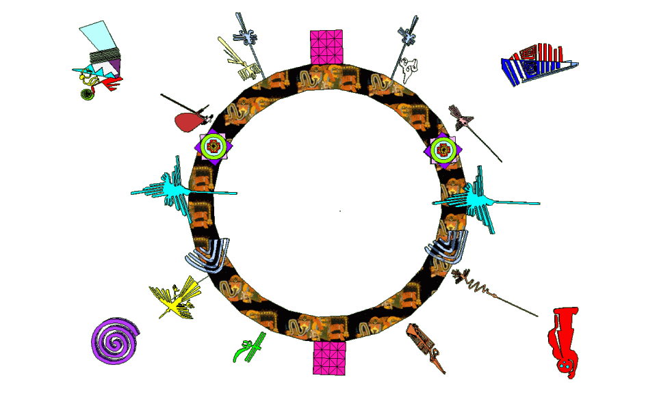
The analysis of alignments led to a possible Ancient Geodetic Model. By plotting this model we arrived to the wheel of birds displayed above, which represents the real heading and direction of bird icons along the ancient geodetic model derived.
Now let's put this model in a historic perspective to see what associations we can infer. We are very well aware of the dangers of analogical thinking, but think about it in statistical terms or number of matches. Sure, it will never bring up the truth, but it may lead to more promising follow-ups.
The Nazca Wheel of birds corroborates Maria Reiche's astronomical theory, the existence of an Ancient Geodetic Model and also delineates some elements of the Nazca Zodiac, associating the birds with the right constellations as well as earth's theoretic alignments. This representation of the sky by using birds is so beautiful! It is also part of other cultures, such as the Australian Aborigines (see above famous Emu in the Sky). Long neck birds (specially snake eaters), big serpent as well as big river, are common denominators to describe the Milky Way, which was a place of reverence and fear, because of the presence of very dark zones such Coalsack Dark Nebula in the Crux Constelation and the Great Dark Horse in the Ophiuchus Constellation.
So what in our opinion is the Nazca Wheel of Birds? - It is the representation of the universe in up and down direction, which by historical tradition is the division of the globe in multiples of 3 (base 3). Since the world may be represented by a series of infinitesimal triangles (or tetrahedrons), 3 is the number associated with the creation itself. At the upper vertice of this figurative triangle (or pyramid) is the place where god is watching the world, with his omniscient eyes, controlling but not being subjected to to the movements below.
Some may argue that this is a Geocentric representation of the universe, but according to modern science it’s a completely valid scientific referential interpretation, if taken as a referential for calculation which is neither unique nor represents the truth. It may just be better adapted to a particular set of theories or scope.
Our interpretation of the birds following wind directions matches Psalter (ca 1260). It also matches Ptolemy's world map (2nd century AD) 3 for each quadrant (30°,60°,90°), Ebstorf Mappa Mundi (1235) has 3 round marks per quadrant, Psalter 1250 has 3 angels blowing winds per quadrant, "Nova totius Terrarum Orbis" by Hendrik Hondius (1630) replace symbols at 30 by sun-moon, Mapamundi del Salterio (1265) has 3 figures per quadrant.
The common elements in these maps are the birds, angels and winds. One should argue why winds were so important and the answer is clear: for navigation purposes. One should be naive to admit that the great navigations after Renaissance have no equivalent in the past.
This way of representing sky disappeared for a certain period of time but, later on, the Herman Moll Map with trade winds (1736) recovers this tradition on cartography. The winds are represented as 4,8,12 and 24 divisions in the wind-rose. The Classical Greek-Roman division is 12 (see wheel below with Greek and Latin Names), usually depicted as winged men or horses (angels and horse latitudes, coincidence?).
The directions of Nazca Wheel of Birds (winds) are real directions after projection. Note that all birds fly in radial directions with exception of Palpa Hummingbird and Parrot (anti-clock movements at 60 and 210 degrees). Relative positions of bird flights are proof of geodetic purpose of Nazca Lines. It is the Nazca way of representing trade winds.
This ancient wind system is a representation of the world in base 3 following the plan crossing the poles. Like the Zodiac it is divided in 12 regions, but its purpose is completely different. The Wind System describes energies believed, in same cases, to be the propulsion system of the objects in the sky. The Zodiac System acts much more as a Universal Clock. Of course, these two systems are related.
The Wind System is commonly depicted as flying horses, pulling the Chariots of the Gods. This figurative system survived as the famous Santa Claus sleigh pulled by 8 reindeers: Dasher, Dancer, Prancer, Vixen, Comet, Cupid, Donner, and Blitzen. Santa Claus may be associated with the god Odin, which by coincidence had a 8 legged horse called Sleipnir; the god Odin himself is associated with the god or planet Mercury. The 8 legs of Sleipnir may also correspond to the 4 twins marking cardinal points or ancient time system(see Denderah Zodiac below).

Author:Unknown. Copyright expired(click on image for details)

Author:Unknown. Copyright expired(click on image for details)

Author:Herman Moll. Copyright expired(click on image for details)

Author: Walrasiad. License :Creative Commons Attribution ShareAlike 3.0 Unported
Note that Psalter's Map is oriented towards east and not north. So, God is equivalent with Sun rising (Sun God). The hands of God make 30 degrees angle and the 2 spheres makes 23.5 degrees and are moved by angels using strings. Jerusalem is at the center. It shows the Earth's axis tilt at the Equator and not Poles. This tradition is inherited from much- much older sources, since it coincides exactly with the astronomical figurative description of the heavens handed to Enoch. The winds in this book are the energies that drive the heavenly bodies. It is possible that ancients would orient their sacred buildings according to this division of the cosmos projected on earth in order to better interact with this energy, which are represented by angels, winged horses or birds. If this is true, it may be considered as the main principle underlining the hypothetical "Ancient Geodetic System".
"And I saw six portals in which the sun rises, and six portals in which the sun sets and the moon rises and sets in these portals, and the leaders of the stars and those whom they lead: six in the east and six in the west, and all following each other in accurately corresponding order: also many windows to the right and left of these portals. And first there goes forth the great luminary, named the Sun, and his circumference is like the circumference of the heaven, and he is quite filled with illuminating and heating fire. The chariot on which he ascends, the wind drives , and the sun goes down from the heaven and returns through the north in order to reach the east, and is so guided that he comes to the appropriate portal and shines in the face of the heaven ...And all these Uriel, the holy angel who is the leader of them all, showed to me." (Book of Enoch-Chapter 72-74).
Note that Enoch describe the Sun movement as circular tilted towards the north at sunset. This symbolism also matches the Norse Mythology, being one of the drawings in the Thor's hammer - Mjollnir (see below). It may be seen as a combination of circular and precessional movement, since the Earth moves like a top. This is also associated with the Horus eyes, as we will futher analyze.
The General Theory of Relativity states that the presence of mass changes the geometry of space and planets orbits are explained by these changes, an image very close to the idea of objects moving through portals or rails in the space. And the same goes with the famous concept of Einstein-Rosen Bridge (wormhole). For those who reached a high understanding of modern science and also the genuine humbleness of the wisdom, the reading of these ancients concepts appear much more plausible than for someone still bound to absolute Euclidian and Newtonian concepts or distorted by religious precepts.
II- THE NAVEL OF THE WORLD: NAZCA AND URARTU
The Quest for the Navel of the World is a very interesting one. Basically all cultures think their location is at the center of the world. This may look like a silly quest, since the only admissible center of the Earth would be in the inner core of the planet.
Let's just rephrase it and instead of calling "Center of the World", let's name it "Referential for Ancient Geodetic System". Some situates it at Giza, but each culture seems to locate it in their capital. Nevertheless, they also claim that they were be first men created, leading to extend their historical capital beyond their normal sacred sites.
Think on it in more practical terms. Imagine that you have to build a world empire, where would you put the capital? The answer would be in a way to minimize the overall cost, mainly transportation. Rationally, this point would be located around the centroid of world lands.
Using the Google Earth Api (now unfortunatelly deprecated), we determined this point by weighting the centroids of all polygons in Google Earth database (this is a rough approximation affected by the distribution of level of detail). The result is relatively close to Giza but not Giza (location 18.02456°,11.45722° - distant 2394 km from Giza). Nazca Lines analysis situates it around the 3 lakes Van, Sevan and Urmia (or within ~300 miles around Lake Van), where the primordial Longitude line lies. We conclude that situating the Axis Mundi in Giza, Jerusalem, Ur and Babylon may not be so primitive as we may think at first look.
Nevertheless the ancient cultures refer to this Axis Mundi in several ways, most related to trees or mountains. We may reduce all this in practical terms, by analyzing the derived Ancient Geodetic System, which would give the referential according to the culture that started building the system (due to the depreaction of Google Earth Api, we are currently updating our documentation).
So, were did this system begin? Nazca Analysis gives an answer to this big question. According to the ancient geodetic system we developed, there are only 2 possibilities for its origin (capital or historic center). It would be located or at the vertex of deltas lines (Great Circles) or where these lines cross the equator. Since we do not have any Nazca Icon correspondent to the second case, the only possible origin for the system is along the line linking Giza and Persepolis. It seems that the ancient empire, which possibly expanded, had it origins in this region.
The Nazca symbol that gives us the key for that interpretation is the solar clock, a clear marker of inflection point. The axis mundi would be at longitude 41°, which would give as strong candidates Göbeklitepe (39°), the world oldest known temple (9,000 BC), but to be more coherent it has to been located around (30.0°,41.4° - The Zero Ground), since this is the exact vertex. Notice that in the Ptolemy's map above the middle angels (90°) are blowing winds in the direction of the Caspian Lake or Persepolis and in the Psalter's map the center is Jerusalem, both very close to our Zero-Ground. The Babylon world map (600BC) is centered on Babylon, and indicates the land beyond the flight of birds to the West (a reference to America?). We know that the double spiral turning in different directions may be associated with the ox horns, which is a common symbol of this region. As a matter of curiosity, just compare the famous Candelabro de Paracas with the trident carried by this god from Urartu.

Author: Charles Gadbois. License :Creative Commons ShareAlike 3.0 Unport.

Author: liveon001. License :Creative Commons ShareAlike 3.0 Unport.
III- THE WHEELS OF SPACE-TIME: NAZCA AND PRECESSION.
We saw the incredible associations with the up-down axis given by the Nazca Wheel of Birds. Despite of the beautiful aspects of this representation it would be incomplete without including another plan, the plan of the equators (celestial and earth's equator).
Our Interpretation of the Calendar is that it represents the abstract plan perpendicular to the up-down line at the center of the earth - which by tradition is divided in power or multiples of 4 (base 4, note that 4x4x4 = 64). This is the same symbol represented by the famous Inca Chakana, which represents the Three Worlds (under, current and upper worlds) and the tree of life.
 ;
;

Comparison of Nazca Calendar with the Inca symbol Chakana. Now, let's briefly verify the parallels between the Nazca representation and others, from ancient civilizations. The best example we can use is the Tablet of Shamash (Babylon 888BC) and the Papyrus of Hunefer (Egypt 1285BC). The dates for these documents refer to container not content dating.
By observing these 2 documents we have the impression they are one and the same: both refers to a judgment process (after-life in the case of Hunefer), a sitting giant god (Shamesh and Osiris), 2 figures accompanying the god or king, A winged deity on top (wedjet–Eye of Horus in the Egyptian case and probably Ashur in the Babylonian case).
We should notice the object in front of the king. This object emanates rays looking like the rays of the sun, which led some to believe it represents the Sun. Nevertheless, if we suppose these documents are really related, the translation to Egypt interpretation is in the form of a lotus flower with the 4 sons of Horus on top. Another thing we should notice is that the sun, as well as the moon and "Venus", are already represented by the 3 small circles on the Tablet of Shamash (close to the ceiling). We think this wheel would better represent the fragile equilibrium of our planet earth. Note that the giant god is at the East and the winged god at the north of the globe.
Let's look deeper in the Shamesh wheel. The overall base is an ocean, which represents the infinite space (or lake of fire). From this ocean emerge 2 pillars or petals (the opposite principles in the infinite space). Then we have the base for the disk and the lotus flower. If we count the globe as part of the lotus flower we will have 3 divisions in both (which means birth of movement and time), coming from the 2 principles. Then the lotus is divided in 4 parts represented by the 4 sons of Horus (4 cardinal points, 4 seasons...). This basis is very fragile, hold by a tiny inclined branch in the Egyptian case and by 2 pillars linked to thin ropes in the Babylon-Sumer case. The ropes and the feathers are the agents capable of change the equilibrium of the axis of the World(axis mundi), which is controlled by the winged god (the god of the sky). So, what we see here is not only the judgment of a person, but the judgment of our world. The winged god can manipulate the axis of the earth like a marionette, based on the judgment of collective human acts.
Since we agree that the disk and the lotus represent the Earth, let's now analyze the best part, which are the angles and the divisions of the earth. The earth is divided in multiple of 3 (12 petals and 12 swirling rays) and in multiple of 4 (4 rays, 4 sons of Horus). Earth's axis tilt is represented by the angle between the 2 ropes and the angle between the wings of the eye ( roughly 23.5° degrees for the ropes). In the case of Hunefer, we need to draw a line from the eye to the center of the lotus, and measure the angle it forms with Horus-Eye wing, which is 21-23°. This shows the extreme interest and respect these cultures have for the precession.

Author:Unknown. Copyright expired(click on image for details)

Author:Unknown-Jon Bodsworth: photographer. Copyright notes(click on image for details)
Putting it all together both documents represent the world, its movement and cycles (base 4) and the cycles and movements of the heavens (base 3).
In the same way, the calendar and Nazca Wheel of Birds represent the Harmony in Heaven and Earth. If we put it all together and compare with the Maya-Aztec calendar, we notice that at the center appears the eyes (poles) and a figure sticking the tongue, symbol of extreme rotation and dizziness, which is the projection of the poles. Above the poles is also the place for Horus or the god of the Sky. The Aztec calendar represents a view from the poles (center) and the plan of equator divided in 8 parts (again base 3 perpendicular to base 4). Note that this common system gives us a generic representation of Pythagoras bases (3 and 4) . You should notice that the 2 green markers on the top of the Aztec Calendar is 23.5° and also the angle of the base of each pointer is 6.5°. We conclude that the Nazca Calendar and Aztec-Sumerian-Egyptian representation of the world are one and the same, and the Earth in all cases is viewed as a Cosmic Clock.
It is very unlikely that primitive people would come up with this same advanced system in different parts of the world. We can also expect as high probable that time-space and cycles concepts are similar to all these cultures.

Author: en:User:Ancheta Wis . License : Creative Commons Attribution-Share Alike 2.5 Generic
Below are the same principles represented by this Urartu Fresco,
combining Egyptian and Sumerian representations: lotus base 3 and wheel base 4,
and Thor's Mjollnir, one of my favorites icons, combining the eyes of god, the
up and down Triskele and the double infinite.

Author:Unknown. Copyright expired (click on image)

Author:Unknown. Copyright expired (click on image)
We could go further and further with examples from all over the world. But let's stop here and make one important distinction. Despite of having the same number of divisions, the purpose of the ancient zodiac is completely different from the vertical geodetic division symbolized by the wheel of angels, lotus or wheel of birds. The first one is used to mark precession time and movement of planets (30*26000/360 = 2167 years per sign), the second is used to mark horse latitudes - trade winds (30) and Polar Front (60). It seems that the location of ancient buildings are better related to these fix geodetic markers rather than the zodiac. Nevertheless, the inner architecture and iconography may be projected to help long counts calculation based on precession. But both principles can also be represented by the same zodiac signs, as we find below in "Schema huius praemissae divisionis sphaerarum" by Peter Apian, Cosmographia (Antwerp, 1539). Note that the two outer circles divisions are dephased of exactly 6.5 degrees (30-23.5).
This cosmographic representation may also be derived from the basic ancient zodiac of Dendera, which is the utmost of all these representations. The outer circle is divided in 8 sectors (the base 4), but the 4 main directions have mirrored images so as the angle between the hands represented by the crossed arms is 13 degrees (2x6.5) or the points where the 45 degrees figure hands touch the inner circle makes 30 and 60 degrees and the first twin figure makes 23.5 degrees. This is clearly a representation of both, zodiac and ancient geodetic system in a very artistic way. Notice that the detail of the twin figures is also represented in the Aztec Calendar but in the form of stylized V shaped pointers for the 4 main cardinal points. This match alone defies all localized explanations, pointing more towards a global ancient system.
You should notice that the starting point of Dendera Zodiac is the top twin figures and the constellation of Sagittarius is just below the top twins. The constellation of Sagittarius is the center of the Milky Way and near the astronomical features Sagittarius A* (between Sagittarius and Scorpio) there is a super-massive blackhole. The drawing of the Long Dendera Zodiac (a rectangular version) shows an empty boat between Sagittarius and Scorpio and also a sitting Baboon inside a circle just before the empty boat (all the other boats have figures). Also the Big Esna Zodiac locates Sagittarius at the center (marked by a bull and ram in different senses) and the region between Sagittarius and Scorpio is full of snakes and winged snakes. The snake also appears in the circular form along the line linking the bow of Sagittarius to the center (close to the right hand of the right twin o the bottom). Would the ancients have knowledge of this super massive blackhole? It is intuitive to think that the snakes (or the birds associated - emu and rhea) represents the Milky Way. It is also intuitive to think that an empty boat represents a dangerous crossing. In the moment that the sun appears to die (winter solstice), marking the shortest day of the year, rising in the middle of snakes, spiders, scorpions and an empty boat should really scare our ancestor, shouldn't it? Imagine if they knew that a star eater monster is just nearby. But this is something we will explore further.
It seems that the ancient civilizations are just fragments of an immense puzzle represented by a mother, more powerful and complex culture. Behind the apparent local stylizations of the iconography, fruits of a synchretic evolution, we find delineated the same complex principle, which would be unlikely to be randomly generated.
The Chinese zodiac (Sui dynasty - 581 AD) below shows the same 6.5 degrees in the division bars of the zodiac and an internal square. The same measurements we will find in the Temple of Heaven (Beijing 39.882242, 116.406469), which northern stairs makes an angles of 13 (6.5x2) and the southern stairs make angles of 30 degrees. The inner circle of the Chinese zodiac has 64 divisions.

Author:Fastfission. Copyright expired Hispalois. Public Domain

Author:Unknown. Copyright expired

Author:Zodiaco_Chino.jpg: Hispalois. Public Domain
The Hindu equivalent Surya Majapahit gives 8 divisions and also 30 degrees angle at base of external rays (30x8 + 15 x8 = 360). Mistaken by the sun, but in reality another example of stylized base 4, base 3, god at the center (Shiva) representation of the earth. The same can be observed in the Kornak Wheel, the small circles on the rays define lozenges and the same angles with center (30x8 + 15 x8 = 360). At the end of each ray we find small concentric circles, defining 13 degrees (2x6.5). The outer circle has 64 small circles or divisions.

Author:Gunkarta. LicenseAttribution-Share Alike 2.5 Generic

Author:Asitmonty. Public Domain.
Note that this explains why the Great Pyramid was built at coordinates 29.97918, 31.13438, instead of on the path represented by the Tropic of Cancer (currently 23.437778, 0). The difference of latitude is exactly 6.541402 degrees, which is close to the angle shown in all the wheels above. The Great Pyramid was built according to the trade winds pattern, as illustrated in the Dendera Zodiac.
We learned from these representations that the common interpretation as the sun god is a mistake. This is the representation of a common Geocentric System, embedding calendar, trade winds, cardinal points, poles, earth's axis tilt, earth's precession, zodiac and sky chart (in some cases). It's an "All-In-One" depiction of the universe seen under Earth's perspective. The associated synchretic elements appear to hide a common scientific root for the system. Nazca derived Geodetic System clearly unveils this ancient root.
Nazca too, is an "All-In-One" system. We will show how The Fox is associated with Canis Major and Sirius, the Monkey with Orion and the Calendar with Cancer (the Calendar may also be associated with the Inca Cross or Chakana).
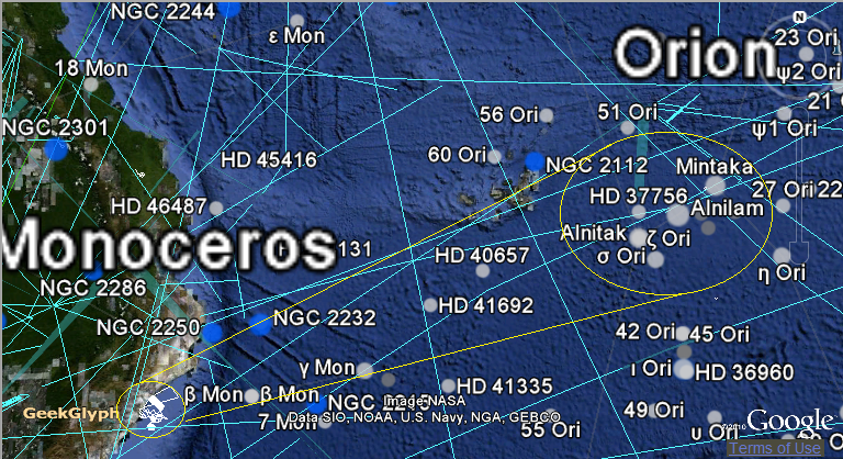
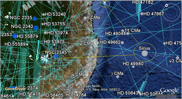
Using the Nazca projection on Earth, we can clearly demonstrate that The Condor flies in the direction of Sirius, The Hummingbird marks the path of the Sun along the Equator and The Spider marches towards Gemini. This can clearly by the screen shots below (since Google Api deprecated, we will just refer to these images).
Note that the Monkey is facing Orion Belt and the Condor is facing Sirius. We conclude by this that Maria Reiche was right all the time, by trying to associate constellations to the icons. Several matches are evident.
 Here we have a major link. The Condor flying to Easter Island and Sirius at
the same time. The fascination with Sirius and Orion would help to explain in
part the alignments of the Ancient Geodetic System. What is not yet explained is
why such persistent fascination as well as the almost perfect match in
symbolism.
Here we have a major link. The Condor flying to Easter Island and Sirius at
the same time. The fascination with Sirius and Orion would help to explain in
part the alignments of the Ancient Geodetic System. What is not yet explained is
why such persistent fascination as well as the almost perfect match in
symbolism.
We should notice that the constellations of Sagittarius, Ophiuchus and Scorpius are related to death of the stars or gods. By coincidence or not, this is the place of a super-massive blackhole in the center of the Milky Way, constantly devouring stars. In other hand the antipode constellations Orion and Canis Major (Sirius) are related to birth of stars or gods. By coincidence or not, the Orion Nebula Messier 42 is a stellar nursery. Did the ancients know all thator are these just speculations? If it is just by intuition, it seems that works perfectly well, doesn't it?
Logically speaking, only a fool would try to predict the End of the World in his lifetime.
If he bet the World would end but it doesn’t, with Great Disappointment he will have to pay for it. But if he bet it would end and it does, he will also pay with his own life. So why so many people dedicate themselves to this craziness?
The term “Great Disappointment” was used when the Baptist preacher William Miller predicted the return of Christ in October 22, 1844, but Christ did not show up.
The same phenomenon happened in our time with the 2000 and 2012 predictions.
We all know that the World will eventually end one day, and that is a fact. So, is 2012 debunk a proof against Maya beliefs of time recycling?
The ones advocating this, forget to mention the problem with the Maya Correlation, which is the synchronization between the Maya Calendar with the Gregorian, using the Julian calendar. Officially, we adopt the so called GMT correlation, which stands from the name of the proposers Goodman–Martinez–Thompson. In the GMT, the Maya creation date is Mon, Aug 11, 3114 BCE and the next long count, the calendar reset, would start in Fri, Dec 21, 2012.
But GMT is not the only correlation, since we have more than 50 hypothesis, ranging from circa 520 years before to 520 years after GMT. One of the most important is the B-B (Bohm and Bohm correlation), which is circa GMT+104 years. In the B-B, the creation date is 4 Aug 3010 BC, or 104 years after 3114 BC, and the calendar reset would be in 2116. A more recent correlation W-F, Wells and Fuls 2000, gives GMT+208 years, or reset date 2220. This last one is incredibly close to the start of the Cosmological Sabbath, 6000 years after Hebrew starting cycle of creation, which is 2239 CE.
Scientifically speaking, the Maya prediction is still possible, but it is a non-sense to take it literally.
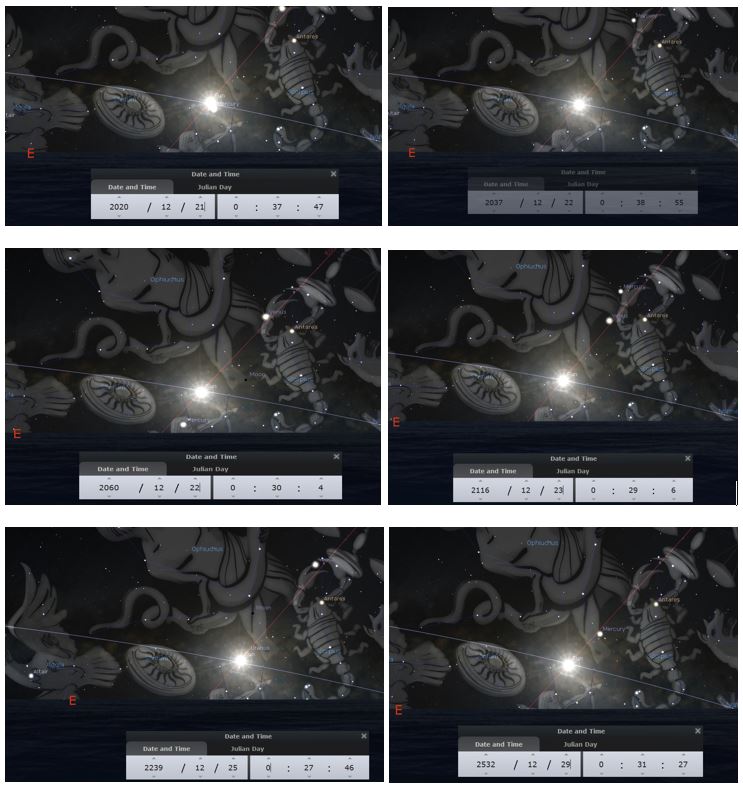
Above is the sky in Jerusalem for several prophetical days. In general the prophecy says that in the winter solstice (20-23 December) the sun will precisely rise at the point where the equatorial galactic line cross the ecliptic line, between Scorpio, Sagittarius and Ophiuchus. The winter solstices in Dec 20 and Dec 23 are rares and the next ones will occur in 2080 Dec 20 and 2303 Dec 23, both are outside the possibilities. We see that the date 2116 is at the limit of this criteria, since it falls in Dec 23. The dates in Jeane Dixon prophecy (2020-2037) as well as Isaac Newton’s (2060) is a perfect match.
Brief, these prophecies would only be considered definitely debunked by 2100, after that only the assumptions of a new astronomical cycle may survive.
We should remember that the month of December corresponds to the winter in the North Hemisphere, which symbolize the death and rebirth of nature. The month correspondent to this same symbolism in the South Hemisphere is June, which the Incas call Inti Raymi (Feast or Resurrection of the Sun). In the South Hemisphere, the sun will not rise in Ophiuchus during the winter of the crossing of Saggitarius, but in the constellation of Orion because, Orion is antipode of Ophiuchus in the sky.
In the Summer Solstice the Sun is at its maximum force and the day is the longest of the year, but after this point the Sun appears to start dying and the Incas commemorate the year that passed and offered gifts to the Sun to assure it would continue to shine, despite of getting weaker and weaker from this point on. The Summer Solstice is called Capac Inti-Raymi.
We think that it is not by chance we have the Condor and the Monkey are the central figures of Nazca.
The Chakana, three step cross possibly related to the Calendar, represents the Tree of Life which has three levels represented by the Snake (underworld or Uku Pacha), Puma (world or Cay Pacha) and Condor (upper-world or Hanan Pacha). The Incas believed that after dying, they would return to the stars, crossing the Milky Way on the wings of this bird. The Condor is the messenger of the Gods.
We conclude that, symbolically speaking, the Resurrection of the Sun in the Monkey Constellation (Inti Raymi) or The Sun Dying in the Condor (Capac Inti-Raymi) should be viewed as a bad year for the Sun, since it should cross the dangerous river (Mayu) at its inflection point. This should be the feeling of the inhabitants of the Southern Hemisphere during the Winter Solstices, both Condor and Monkey (antipode constellations) appearing in the sky at the same time, with the Sun located in this dangerous spot. If the Inca Myths are similar to the Nazca Myths, and everything indicates some inheritage, the Nazca Lines are also an alert to the dangers, at least symbolic, of the precessional cycles marked by the year apparent rising of the Sun in a dangerous place of the sky.
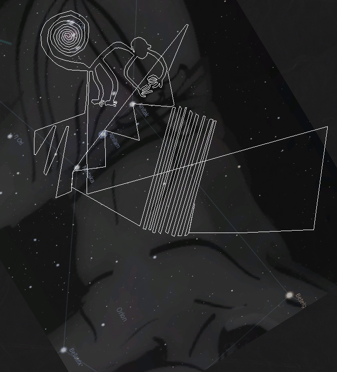
Now we present our interpretation of the Monkey as constellation, which we think represents part of the Orion Constellation. The Orion Belt matches the base of the three pyramids and the spiral matches the Orion Nebula Messier 42, which is visible to the naked eye. Historically, the Inca Chakana (3 stepped cross) is associated to the Orion Belt.
Regarding the Monkey, it can be a monkey or a sitting person associated to the Chakana (stair). The Spiral is the Orion Nebula, which is a source of stars (life) in the Universe.
Another constellations clearly related to the local star lore is the Condor (Contor), which is associated with the constellation of Scorpio, and the Pile or House, which is associated with the constellation of Taurus (more specifically the Pleiades and Hyades).
The Milky Way was associated with a river (Mayu). Besides the bright constellations, the Incas were very interested by the dark areas in the Milky Way, more specifically around Sagittarius and Scorpio: The Fox (Atoq), The Condor (Contor), The Serpent (Mach'acuay) and others.
(source: The Incan View of the Night Sky: Stars, Constellations, and Dark Clouds www.astronomy.pomona.edu).
It is possible that the Incas inherited part of their star lore from Nazca culture. If the Condor is really around the Scorpio neighborhood, the line linking the Monkey with the Condor would indicate the path of the Milky Way and we would be able to name the other Nazca figures by matching their positions.
This fascination with the Mayu, or Milky Way, would explain the high concentration of geoglyphs along its representation: Spider (Serpens Cauda), Frigate Bird (Cygnus), Arrows (Cassiopeia), Spiral (Corona Borealis), Tree and Hands (Aquarius).
Monkey, Orion and the birth of stars
 Note that not all symbols in Nazca are associated to stars, but there
is a clear correlation between places and stars in some cases and that is the
case of the Monkey and Fox. Nazca is not a map of the skies, but appears to be a
World Map and Historical account of Explorations, with some elements of the sky depicted on it as well as air and water
mass movements, which is a widespread
practice in ancient cartography and navigation.
Note that not all symbols in Nazca are associated to stars, but there
is a clear correlation between places and stars in some cases and that is the
case of the Monkey and Fox. Nazca is not a map of the skies, but appears to be a
World Map and Historical account of Explorations, with some elements of the sky depicted on it as well as air and water
mass movements, which is a widespread
practice in ancient cartography and navigation.Mapping the Earth seems to be not only a project on paper but a real enterprise of establishing geodetic markers on real sites, making the earth a giant cosmic time-space referential system. The question is why bringing this curiosity to an enormous geographic scale, which would only make sense from outside earth's sphere itself? Why undertake such a big project requiring several generations? - A hypothetical common civilization with this kind of sophisticated scientific base would probably act in overall rational terms, not guided by unfounded superstitions.
This system is derived from a generalization of the Pythagorean Theorem. The formulation of Modern Relativity Theory is also an application of Pythagoras in 3 dimensions using Euclidean space and including the 4th dimesion time, or better explained by integrating timespace using Minkowski formula for distance, where time appears as a 4th dimension s2 = x2 +y2 +z2 - (ct)2 , where s is distance, xyz are space coordinates, t is time coordinate and c a constant. Minkowski original formula appears exactly as Pythagoras in 4 dimensions by treating time as an imaginary or complex concept. This may be not necessary in pratical terms, but is much closer to the ancient separation of the wheels of space and time.
We are also interested in more practical feedbacks. If we determine the center and the layout of "The Ancient Geodetic System", it would lower cost for further location of important Archaeoastronomy Sites under the dust and mud of time, bringing forgotten pages of our history back to life. So, what we are building is in some sort a predictive model which should be adjusted and tuned up as discoveries are made.
IV- THE UNEXPLAINABLE: NAZCA AND ANCIENT ASTRONAUTS THEORY
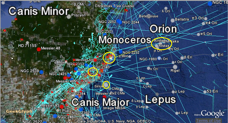
We saw that the Monkey is associated with the Orion Constellation. Its projection faces straight to it. Nazca System, which also includes Palpa and Ingenio Lines, has two Orion connections: the first one is in the South Hemisphere, represented by The Monkey, the second one is in the North Hemisphere represented by the Triple Spiral projected in the Lake Urmia. Notice that Lake Urmia in Iran, Lake Ururu in Bolivia, Orongo and Ura Uranga Te Mahina in Easter Island are all connected and present very interesting phonetic and geographic "coincidences"!
The match of the Lake Urmia is so amazing that deep archeological researches in this area is highly recommended. The Triple Spiral is associated with the star Beta Boötis (a yellow giant only 219 light years from Earth) and in the Boötis Constellation we find Tau Boötis Ab, which is a planet approximately 50 light-years distance. See Nazca projection on Lake Urmia below. The distance between Nazca and Urmia is 13,667 Km (close Earth's diameter: 12,742 km). Amazing, right?
Triple Spiral on Lake Urmia and Solar Clock on Lake Van. An incredible match!!
The Monkey facing Orion and the cross over Alnilam.
The Condor facing Sirius and Fox marking the Canis Major Constellation.
Below we illustrate our interpretation of the monkey symbol compared with Lord Pakal (image flipped vertically, both facing and representing the trip to Orion, accompanied by a bird). We flipped the symbols because they correspond to different hemispheres. The monkey or sitting person is in the same enigmatic position as Lord Pakal and Easter Island Birdman.
Note that a stick coming out of the bottom of the monkey does not mean a third leg or some other body part. The same happens with the spiral, this shape may or not be interpreted as a tail, but the consequences of choosing one or another changes the whole meaning of the drawing. We think it is not a tail.
In this case, the monkey is really a person sitting in an enigmatic position. It is not in a fetal position, because in this case the legs would normally be crossed, and neither the travel to the underworld, because in this case the hands would normally be crossed.
Pakal sarcophagus lid is interpreted as the Maya Tree of Life. This is a fair interpretation, considering the similarity with the tablet of the Temple of the Foliated Cross in Palenque, which shows the Maya Tree of Life with Kan B'alam II on the left side and Lord Pakal on the right (very similar to the Babylonian Tree of Life). What is strange is that nobody really know what the tree of life is and in both, Babylonian and Maya case, is depicted as some sort of articulated mechanical device. The Monkey too, give us an impression (illusion or not) of some kind of trip to the stars using no ordinary devices, the bird being represented by the Condor (Scorpio) situated just in face of the Monkey. This is the classical depiction of the travel to the stars (Orion) by crossing the Milky Way (bird). What is strange is the symbols used to describe this trip, articulated mechanical mechanisms and computer, related more to modern space travel than to ordinary after life journey to the stars. Would it be farfetched to think on a dangerous intergalactic space travel catapult process using forces in the center of the galaxy?
So what are the Monkey and Pakal doing? Flying? Working on some sort of computer? The truth is that the imagery and artifacts associated to the so called out of place elements are amazing and deserves to be considered as some kind of evidence, at least regarding our complete ignorance on the subject.
In our opinion there is no better example of that than the lid of Lord Pakal sarcophagus. It really looks like some kind of machine, be it derived from pure imagination or from real more practical needs. The same visual sensation happens with the figure of Nazca Monkey, which really looks like Pakal sitting in front of a computer.

Pakal: Author:Unknown. Public Domain.
We can not say much about these visual sensations. But, in other hand, we can say a lot about incredible alignments, because the odds of this can be statistically calculated. That is the case of the fantastic alignment shown below.
These 3 world icons are perfectly aligned (less than 70 miles in Earth's scale). The Kneeled Moai (only sitting moai with beard) seems to be the most appropriate match. Note that all these figures follow a coherent measure for the local heading along the line linking Easter Island-Giza: Kneeling Moai ~75, Nazca Astronaut ~63.5 and Sphinx ~90. It works like this: Kneeled Moai give it's back to Nazca Astronaut but faces Sphinx, Nazca Astronaut Faces back of Kneeled Moai which faces Sphinx (see the free map tool we built for this kind of analysis). Briefly, the aligned icons face the Sphinx. Remember that we are not talking about straight line on the Euclidean plan, but straight lines on earth surface (which are in reality not straight lines). The odds to get this as a random alignment are very small, and much smaller to have a coherent heading angle. To achieve this technological wonder the ancients would have to have a wonderful technology. And the tools and efforts are there as visible proof on all the scattered megalithic structures around the globe.

Photo: Mila Zinkova Lic: CC Attribution-Share Alike 3.0

Photo: Raymond Ostertag Lic: CC Attribution-Share Alike 3.0

Photo:Eigene Aufnahme Lic: CC Attribution-Share Alike 3.0

Author: Rivi Lic: CC Attribution-Share Alike 3.0

Photo: Nina Aldin Thune - Nina Lic: CC Attribution-Share Alike 3.0
Nazca precise alignments and geometry along with the "Antikythera Mechanism" (a computer dated 150BC) are the clear proof of our ignorance about our technological history. If we can have a sophisticated computer, ever-lasting buildings and complex representations of space-time, why not some other not yet discovered machine or scientific theories?
A typical argument against the achievements of advanced past civilizations is that if they were so advanced why were they militarily defeated and their constructions only made of enormous stones. This is a typical misunderstanding of the social structure in the past as well as the confusion between information as a product in our society of mass consumption and concentration of information in theocratic societies. Destroying a theocratic society may be compared as destroying the queen in a beehive and the conquistadors knew that very well. The "building only in stones" argument is ignorant in its base, trying to relate these civilizations to stone age people. Other more rational choices of material were in general available to ancient civilizations and it is not the use of stones that is intriguing but the technological level achieved on transporting, cutting and aligning them, without visible appropriated tools. This type of social behavior, not in favor of the lowest cost but the ever-lasting, was a typical way of showing power and divine mandate in Theocracies.
A very pertinent question, tough, is why such fascination with the sky, flood myths, geodetic markers and even very long time cycles? Just for religious purposes...not likely, just to guarantee good crops...much less. Maybe the sky is where we really belong to and myths are not myths after all, but the result of another state of conscience that fades with time along with the fabulous Nazca Lines.
V- THE UNBELIEVABLE: NAZCA AND ATLANTIS
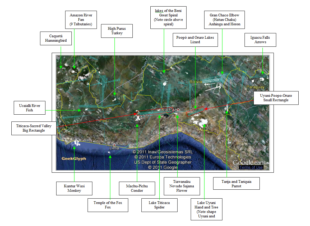
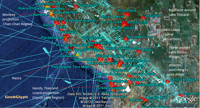
The Nazca Map was calibrated based on the South America Region as follow. Notice the major points for calibration: the shape of The Hand is similar to the shape of Salt Lake Uyuni, The Great Spiral closely matches The Round Lakes of Beni , The Arrow points to Iguaçu Falls, the two Central Rectangles identify the two levels of the Andean Altiplano, The Spider is crawling from Titicaca to Cuzco, The Condor flies over Mach-Pichu and The Monkey indicates the Peruvian corner of Chan-Chan area.
By considering the entire Nazca Cluster (Palpa, Nazca and Ingenio), we projected all the elements in the globe and analyze them using some basic observations: the great circle linking Sphinx, Kneeled Moai and Nazca Astronaut makes 30 degrees with the Equator, it also respects the Heading of the corresponding Icons, some Icons are clearly related to Tropic and Equator lines. We then repeat this angle to generate the Ancient Geodetic Model. The geometrical, geographical and historical results are amazing, as explained below.
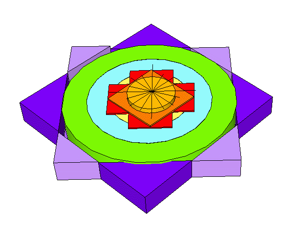
In order to impose ourselves the maximum rigor, we chose the model with the minimum number of lines. The simplest geodetic model is the one with 4 centers (2 being antipodes), which is represented by the square at the equator. From each center we irradiate 12 lines spaced 30 degrees, representing the trade winds and following the schema of the Ancient Geodetic System explained above. One of these lines is identified with the Delta Line (or Great Circle). From each center we create concentric circles every 15 degrees, which divide the Equator in 24 segments corresponding to the divisions of the day. The main intersections are defined by the yellow circles, representing peak of spherical harmonics.
By projecting Nazca Lines on Earth we realize that the whole cluster matches this ancient geodetic system as clearly explained in the images below.
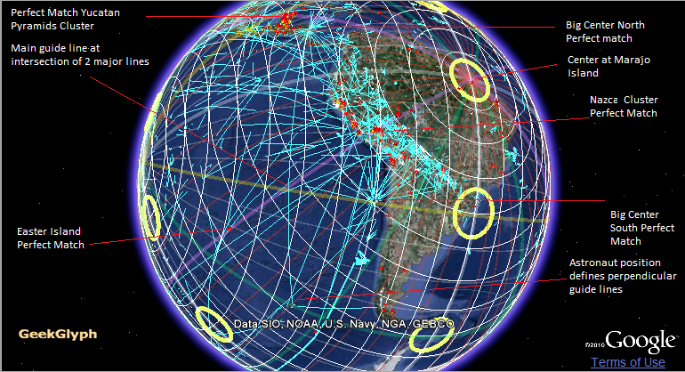
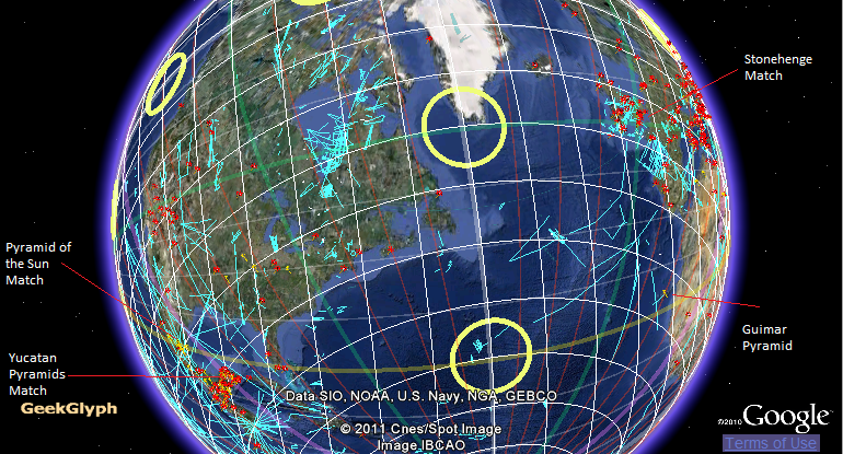
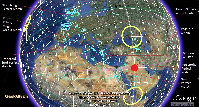
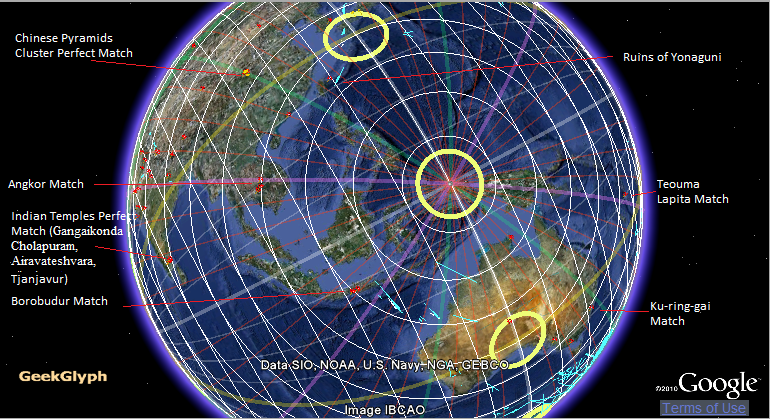
The perfect match of the 2 big centers, as well as Nazca figures, with the concentric circles created from Marajo Island (Brazil) and the perfect match of Trapezoid bird and Palpa Pelican with the concentric circles drawn from African center, indicates that the system follows precise spherical geometry rules, coincidence or not.
Another point interesting to be noticed is that the main wind-rose of Piri-Reis map is very close to the Nazca wind-rose (the Calendar). The coordinates of the Calendar are around 23.5°,-48° and match the ones of Piri-Reis map (23.5°, -42.6°). Note that Piri-Reis map has 2 main Atlantic wind-roses: 23.5°, -42.6° and -27.8°,-21.3° (Prime Meridian). The Second wind-rose matches the intersection of 2 major lines (multiple of 30°) in the Nazca Mathematical Model. Note also that the Big Center of Nazca Lines Icon (-27.8,-74.3) has the same latitude as Piri-Reis South Atlantic main wind-rose. These are important points used for triangulation purposes.
We also noticed that this model seems to have triple purpose: geographical, chronological and astronomical. It was as if there has been an attempt to project the celestial sphere on the earth and use this projection as geodetic and astronomical predictive model. This would help to explain the abandoned cities and monuments with the time, since they were built according to a sky pattern no longer the best in predictive and observational terms ("not under the favor of the Gods").
The match with all well known ancient monuments, mainly the pyramids, points to a more incredible explanation: it may be the indication of sites projected according to a common layout coming from an ancient civilization or civilizations derived from the same cultural root. Is that Atlantis and its children civilizations?
If this assumption has a strong foundation, it should be present in some of the theories on Atlantis. The fact is that this assumption has an almost perfect match with Jim Allen theory, which situates the lost continent in South America and the lost city in the Bolivian Altiplano (Pampa Aullagas). Notice the big plane and the small plane are basically the same pointed out by Jim Allen around lakes Titicaca and Poopo-Oruru. If Pampas Aullagas is proven to be Atlantis, then the Lizard, Tree and Hands would be the icons representing it.
The other clusters around the Earth would indicate the children or associated and derived civilizations. Notice how they seem to match the map presented by Donnelly, considered as pseudo-science. It seems that Donnelly got most of it right, with exception of Atlantis Island itself and the Hudson Bay cluster. Also, the fact that the South America cluster is so big does not mean that the Atlantean Civilization has historically originated in this area (main center does not means historic center). The most probable location for the historic center is within 800 miles (1287 km) circle around latitude 30.0° and longitude 41.4° (as we discussed above), which is roughly the location of the city of Sakakah (Saudi-Arabia). Archeological sites in the Area

Author:Ignatius Donnelly. Public Domain.
Now we present the Ancient Geodetic System with 8 centers (4 antipodes). The first view is taken from the North Pole and is similar to all the wheels presented above (base 3 and base 4 clearly depicted). The second view shows the Equator at Marajo Island-Brazil and reveals other interesting aspects: :
- It clearly shows the infinite symbol at the Equator or the Sun Path (one of Thor's symbol).
- It clearly shows "god's eye" as a circle inside a lozenge or Horus Eyes.
- It clearly shows horse and polar latitudes as well as both tropic lines.
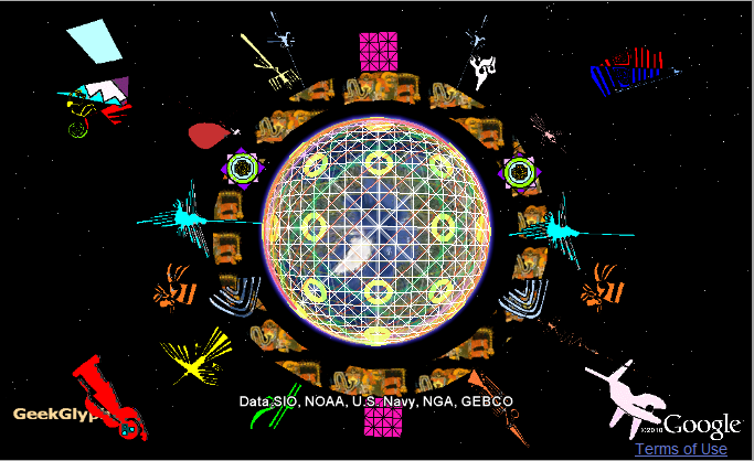
Let's talk about the God's Eye (The All Seeing Eye). It is a curious symbol, usually misunderstood. Let's take the original Egyptian Horus Eye. It represents the Ancient Geodetic System at the Equator (see 2nd figure above) and clearly includes the angles 23.5, 30 and 60 (see figure below from wall relief at Kom Ombo). Also notice the bench beneath the eye, the same seen in the Tablet of Shamash, which indicates the 4 divisions. Even the modern representations preserve these same angles. The Horus Eye is also associated with the series of numbers 1-1/64 = 1/2 + 1/4 + 1/8 + 1/16 + 1/32 + 1/64 (according to Egyptian Mathematical Leather Roll). So, the eye was part of a measurement system with 6 terms (short of 1 by 1/64) and 1/ (4^3) last term (again 3 and 4 bases). Note the parallel between this system and the Chinese hexagrams. If there is an ancient geodetic system it would reflect this same principle. Was it an ingenious way to represent the 4 dimensional World in a surface?


Author: Rémih. License : Creative Commons ShareAlike 3.0 Unport.
We would not present our idea of existence and layout of the Ancient Geodetic System without tangible evidences to support it. That’s is what we are going to do now by choosing one kind of common and famous structure (the pyramids-mounds-huacas) and measure the distance from the main lines crossing the centers (6 lines) in the 8 division system (4 centers - 4 antipodes).
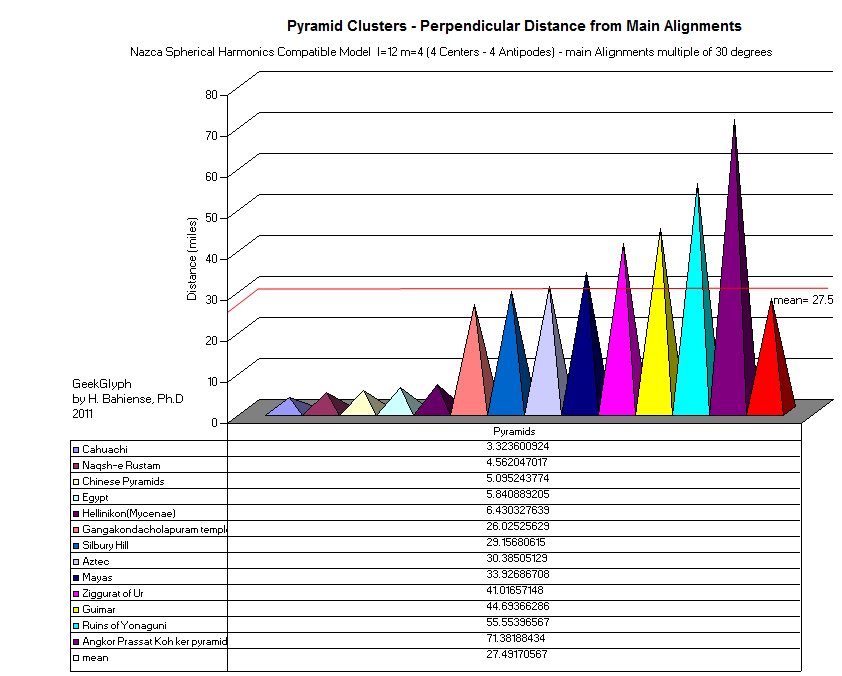
The probability for each individual cluster to be randomly positioned is roughly 1.12%, considering lines maximum width 70 miles. So, we can say that each individual cluster has a probability of more than 98% of being positioned in a non random way (which may due to other variables not well understood). The average distance from main lines (0, 30, 60, 90 degrees) is presented above. Notice that some pyramid clusters are very concentrated (Giza, Chinese) and other very scattered (Mayas).
Not only the old cities and monuments are laid out according to this system, but it is amazing how it accommodates new cities in the New World too. The influence of Masonry on the layout of capitals of the Americas is a well known fact. It is also known that Freemasons proclaim they are guardians of ancient knowledge, looking to apply the principles inherited from ancient civilizations to recent architecture. If Freemasons really know or not these mysteries is beyond the scope of our analysis, but if it is the case it would be visible in the monuments and cities layouts were their influence is proved fact: the New World. Here we present the correlations between The Ancient Geodetic System and Capitals or Historical Centers of the New World and, as we can see, the major lines cross several major cities in their metropolitan regions. This list is much bigger if we consider other cities (not only capitals) and secondary lines (not only multiple of 30).
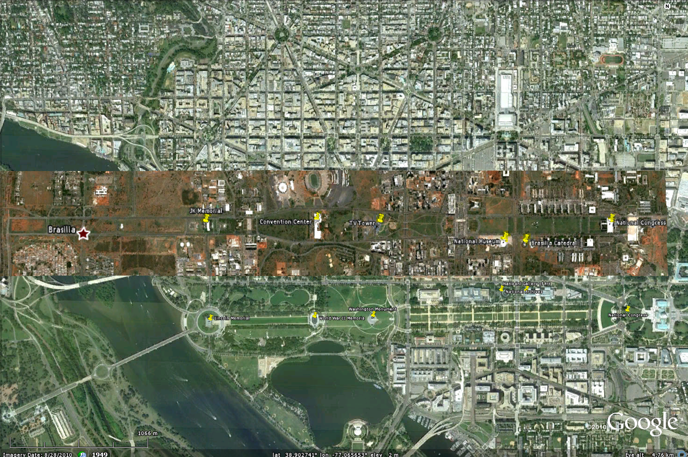
| Line | Reference Center | Distance (miles) | |
| Brasilia | 90° Line | Marajo | 20 |
| Washington DC | 60° Line | Marajo | 13 |
| Mexico City | 30° Line | African | 20 |
| Managua | 60° Line | Antipode- Indian | 4 |
| Quito | 0° Line | Marajo | 0 |
| Caracas | 30° Line | Marajo | 15 |
| Cuzco | 30° Line | Marajo | 20 |
| Santiago | 60° Line | Marajo | 7 |
| Asuncion | 30° Line | Marajo | 10 |
From this list, we should retain only the 2 first cities as deliberately positioned to be the capitals and laid out according to precise plans and Masonic influences, which is a well known historical fact. According to William Almeida de Carvalho ("Pequena História da Maçonaria no Brasil", 2010), the plans to build Brasilia go as futher as 1823, at the time of "Grão-Mestre" Jose Bonifacio (the Brazilian equivalent of Benjamin Franklin). The other aspect to notice is that Brasilia is at the center of the spherical harmonic peak and Washington at the valley. The big avenue is presented in both cities, but Washington heading is 90° (East - Sunrise) and Brasilia is 107°. Why is Brasilia oriented according to this strange angle? The answer maybe that is exactly the heading of the direction 247.5 from Indian Center (0, 86.56562), which means that Brasilia was laid out according to 1st center (position) and 4th center (heading). In astronomical terms, Brasilia is oriented according to Sirius (winter solstice 1821-1823 at 5AM - Sun and Sirius at horizon and Sirius is exactly at 107°). In other hand, Washington DC is oriented exactly to the the Pleiades (4th July around 1790-1800, 6AM) or Aquila in winter Solstice. In one side, the sky and time gives us the orientation, in the other side the winds and the Ancient Geodetic System give us the location of cities and monuments. Isn't that beautiful?
We are not interested in conspiracy theories around Masonry, but simply recognizing the past role of this organization in the choice of the location and layout of important cities in the New World.
Our representation of the Ancient Geodetic System was entirely built from Nazca Icons and Lines. From those we arrived to some sort of Universal Representation of the World and a better understanding of the so called religious symbols of antiquity. This is a complete different and practical approach for analyzing religion in the past and mysterious iconographies in the present, allowing to convert elements from one system to another based on a common key (as we did by comparing lotus and wheel above). Each god and each symbol is unveiled as part of the same scientific symbolic language of Theocratic Societies, removing the mud of superstition from our common and glorious past. We hope this system will be able to open new horizons and help further investigations on the subject.
From our macro-analysis we clearly demonstrate the following:
1- Nazca seems to be part of an ancient geodetic system. This argument is reinforced by strict spherical geometry matches and the possible inheritance of the Ceque System.
We managed to rebuild a great deal of this system as we started analyzing it.
2- Nazca seems to encode the same principles of the Maya-Aztec Calendar, as deducted from the Wheel of Birds and Calendar.
We think that both have common elements from Sumerian and Egyptian time-space concept (as explained below).
A geographic analysis is related to an overall concept of time-space, which seems to have very clear common roots,
based on Pythagorean triples (bases 3 and 4, resulting in 5).
3- Nazca projection matches multiple elements of Jim Allen Bolivia Atlantis theory.